Welcome to the Bright Idea Zone!One toy, many ways to play
Unearth intriguing facts and information that will delight learners of all ages and enhance the placemat experience! Do you want to share the fun with your children off the screen? Simply click to download the printer-friendly children’s version of this page or access your bonus printable coloring pages. Get ready to embark on an educational adventure!

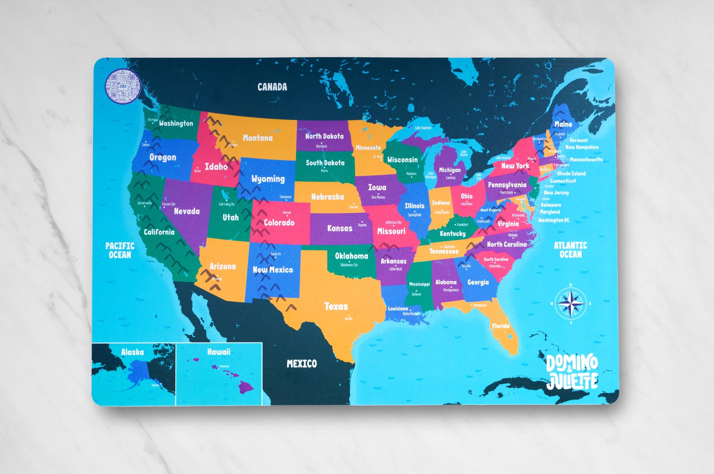
Domino and Juliette was “born” in the great country of the United States of America (USA). It’s our home-sweet-home and is part of North America, one of the 7 continents on planet Earth. Because the US is located above the Equator, we say it’s placed within the Northern Hemisphere. And see that fun circle and star on your map? That’s the compass rose that tells you the directions:
North, South, East and West.
The lines pointing in between those directions indicate the positions:
Northeast, Northwest, Southeast, and Southwest.
The compass rose helps you figure out which way you’re facing and where you need to go. It serves as a guide to keep you from getting lost!
But what about all the details that make up the US? Sure there are memorable landmarks and other iconic pieces of history dispersed across the country, but what about the terrain, the land and the water that composes such a beautiful place? Let’s learn about this together!
Did you know about 71% of planet Earth is covered in oceans? That’s a lot more water than land! The five oceans on Earth include the Atlantic Ocean, the Pacific Ocean, the Indian Ocean, the Southern Ocean, and the Arctic Ocean. North America is surrounded by two of these oceans: the Atlantic Ocean on the east coast and the Pacific Ocean on the west coast (take a look at your compass rose if you need a refresh on East and West). The coastline of North America is very long and also very jagged. This means that it has a lot of bumps and curves in it instead of being a straight line. This is called a "jagged coastline."
The Atlantic Ocean is the second-largest ocean on Earth. It's also the saltiest ocean. It’s located on the eastern side of North America (on the right side of your map) and is named after the ancient civilization of Atlantis.
To the left of the US, or the western side, is the Pacific Ocean. The Pacific Ocean is the largest ocean on Earth! It's also the deepest ocean. It's named after the word "peaceful," because early explorers thought it was a calm and peaceful ocean.
Now that we have gotten our feet wet with the oceans, let’s get back on land!
North America is a very big continent and is home to many countries including: Canada, the United States of America, and Mexico. A country is a geographic region or territory that is recognized as a separate political entity. Each country has its own government, laws and culture, and its citizens have certain rights and responsibilities. Countries are typically defined by their borders, which are often based on natural or man-made features such as rivers, mountains, or political boundaries.
Canada, the United States, and Mexico are known as North American neighbors. Hey neighbor! Canada is located to the north of the United States, and Mexico is located to the south. The three countries share a common history, as well as cultural and economic ties. They also share borders and work together on a variety of issues such as trade, immigration, and security.
Canada is a country located in the northern part of North America (shown in dark green on our placemat). It is the second largest country in the world by land area. Canada has a population of approximately 38 million people, with a diverse culture that includes Indigenous peoples, French and English-speaking communities, and immigrants from around the world.
Mexico is a country located in the southern part of North America (also shown in dark green). It is the third largest country in Latin America by land area. Mexico has a population of approximately 128 million people, with a diverse culture that includes indigenous peoples, Spanish-speaking communities, and many other ethnic groups.
On your USA Geography placemat, we’re focusing on the United States of America, which is sandwiched between Mexico and Canada! The United States is the third largest country in the world by land area. The United States has a population of approximately 331 million people, with a diverse culture that includes people of many different ethnicities and backgrounds.
The United States is divided into 50 states, each with its own government and set of laws. The states are all located within North America, and they vary in size, population, and culture. The states are represented on the United States flag by the 50 stars, one for each state. On our placemat, each of the states is shown in a different color. If you live in the US, take a second to locate the state in which you live!
Alaska and Hawaii are two states that are not located within the contiguous United States. “Contiguous” is a fancy word for touching. Alaska and Hawaii are not touching or bordering the other 48 states and so aren’t possible to show in their actual locations on our map. As a result you’ll see we have placed them in small boxes in the lower left hand corner of the placemat (It’s important to remember these are not their true locations!). Alaska is located to the northwest of Canada and is the largest state in the United States by land area. Hawaii is located in the middle of the Pacific Ocean and is made up of a group of islands.
On our placemat, each state is labeled in large lettering. You will also find labels for capitals. A capital is a city or town that serves as the center of government for a country or state. It's where the leaders of the government work and make decisions about how to run the country or state. In the case of the United States, the capital of the country is Washington, D.C. It's where the President of the United States and other important government officials work. Washington D.C. is not located within any state. Instead, it is a federal district that was created specifically to serve as the seat of the federal government.
But let’s get back to the land of the free–let’s get back to the dynamic, or diverse, terrain that makes up the US.
The United States is made up of many different land features like mountains, lakes, rivers, and coastlines. These land features provide important resources and habitats, or homes, for plants, animals, and people, and they also offer opportunities for outdoor recreation and tourism.
On your map you will find many different mountain ranges including the Rocky Mountains, the Appalachian Mountains, and the Sierra Nevada Mountains. These mountains provide important habitats for wildlife and also offer opportunities for outdoor recreation like hiking, skiing, and camping. Pause here and ask a parent if they’ve visited any of these ranges! Do they have pictures or stories from their visits? Have you been to any? Maps and the appreciation of the US always are most memorable when you have had personal experiences there.
If you’ve heard the phrase “I’m on top of the world”, you might find yourself on a mountain. Literally. If you’re in the western part of the US, then you’re on top of the Sierra Nevada Mountains. These mountains are primarily in the state of California, but also extend into the states of Nevada and a small part of eastern Oregon. The Sierra Nevada mountains are known for their stunning beauty, with towering peaks, deep canyons, and crystal-clear lakes. They’re home to many different national parks and wilderness areas including Yosemite National Park, Sequoia National Park, and Kings Canyon National Park.
Move a smidge more east and you’ll bump into the Rocky Mountains, a range of mountains stretching over 3,000 miles (4,800 km) from British Columbia in Canada to New Mexico in the southwestern United States. The Rocky Mountains are famous for their rugged beauty, with towering peaks, deep canyons, and pristine lakes and rivers. The Rocky Mountains are a popular destination for outdoor enthusiasts, with opportunities for hiking, camping, fishing, and skiing. Some of the best ski resorts in the world are here including Vail, Aspen and Breckenride in Colorado, as well as popular resorts in Utah, Wyoming and Montana. The area is home to many different national parks and wilderness areas, including Rocky Mountain National Park, Yellowstone National Park, and Grand Teton National Park. These mountains have been an important source of natural resources, including gold, silver, copper, and coal. They’ve also been an important source of water for many different communities throughout the western United States.
Let’s head even further east and explore the Appalachian Mountains, a range of mountains that run from eastern Canada down to central Alabama in the southeastern United States. They are known for their lush forests, scenic beauty, and unique cultural heritage. The Appalachian Mountains are a popular destination for hiking, camping, fishing, and hunting. The area is also home to many different national parks and wilderness areas including the Great Smoky Mountains National Park, Shenandoah National Park, and the Appalachian Trail. The region is richly known for its bluegrass music, old-time music, and traditional crafts such as quilting, pottery, and basket weaving. There’s something for everyone in the Applachians!
Another beautiful land feature found in the United States are lakes. A lake is a large body of water surrounded by land. Lakes can be formed in a variety of ways, such as by glaciers, rivers, or volcanic activity. They can even be man made. They are important habitats for many different types of fish and other aquatic animals, and they can also be popular destinations for recreational activities like fishing, swimming, and boating.
Located in the northeastern part of the United States and the southeastern part of Canada are the Great Lakes. The Great Lakes are the largest group of freshwater lakes in the world and include Lake Superior, Lake Michigan, Lake Huron, Lake Erie, and Lake Ontario. They contain over 20% of the world's freshwater supply. Lake Superior is the largest and deepest of the Great Lakes, and is so big that it could hold all of the other Great Lakes plus three more Lake Eries! Lake Michigan is another Great Lake and is known for its sandy beaches and clear blue water. It's a popular destination for boating and fishing.
There are a handful of other large lakes on our map that are not labeled. One of them is Lake Tahoe which is located in the Sierra Nevada Mountains on the border of California and Nevada, Lake Tahoe is known for its stunning beauty and crystal-clear water. It's a popular destination for skiing, hiking, and water sports. Another famous lake is Crater Lake which is located in southern Oregon and is the deepest lake in the United States and known for its striking blue color and scenic views.
From the highest highs to the lowest lows, the US is created with some of the world’s most unparalleled diversity when it comes to its geography. We hope this little exploration has piqued an interest to further learn about your home country, be it the US or elsewhere, and has deepened an appreciation of both land and water—the bones and muscles of planet Earth.